Research
Three connected research themes — GeoAI and multisource remote sensing, urban environmental health, and climate risk and community resilience.
My research program asks a single connected question: how do urbanization, climate extremes, and environmental inequality shape human health, community resilience, and sustainable development — and how can satellite observation and geospatial artificial intelligence answer that question at the scales where decisions are made?
The three themes below build on one another. Methods developed under GeoAI and multisource remote sensing supply the exposure and land-change evidence used in the two applied themes.
observation
spatial modelling
& climate shocks
outcomes
GeoAI and multisource remote sensing
I develop geospatial artificial intelligence methods that fuse optical, SAR, LiDAR, hyperspectral, and nighttime-light observations into consistent, decision-ready maps. This work combines machine learning and deep learning with physical understanding of the urban environment, and scales through cloud platforms such as Google Earth Engine.
Key questions
- How can multisource satellite observations be fused when clouds, shadows, and sensor differences make any single source unreliable?
- How do we make deep-learning-based mapping transparent enough to support environmental policy?
Methods. Deep learning and machine learning, data fusion, sparse representation, fuzzy-set approaches, Google Earth Engine, spatially explicit modelling
Scale. City to global; annual to intra-year time series
GeoAIremote sensingSARLiDARhyperspectralnighttime lightsdeep learning
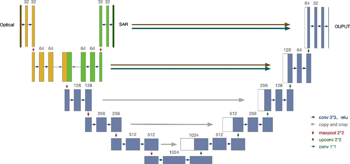
UU-Net fuses optical and SAR imagery to extract roads at large scale. Fig. 2 of Lin et al. (2021), Int. J. Appl. Earth Obs. Geoinf. (CC BY-NC-ND 4.0).
Selected publications
Urban environmental health
Cities concentrate people and environmental hazards. I quantify urban heat, air pollution, and their compound exposure at the scales where people actually live — buildings, neighbourhoods, and communities — and link them to mortality risk, health inequalities, and the social determinants that make some populations, including older adults, more vulnerable than others.
Key questions
- How much larger are health risks when urban heat islands and air-pollution islands compound, and who bears them?
- Which communities face the greatest combined environmental burden, and why?
Methods. Satellite-derived exposure mapping, structural equation modelling, multiscale spatial analysis, health-registry linkage
Scale. Building and community scale to global city samples
urban heatair pollutioncompound exposuremortalityenvironmental inequalityageing populations
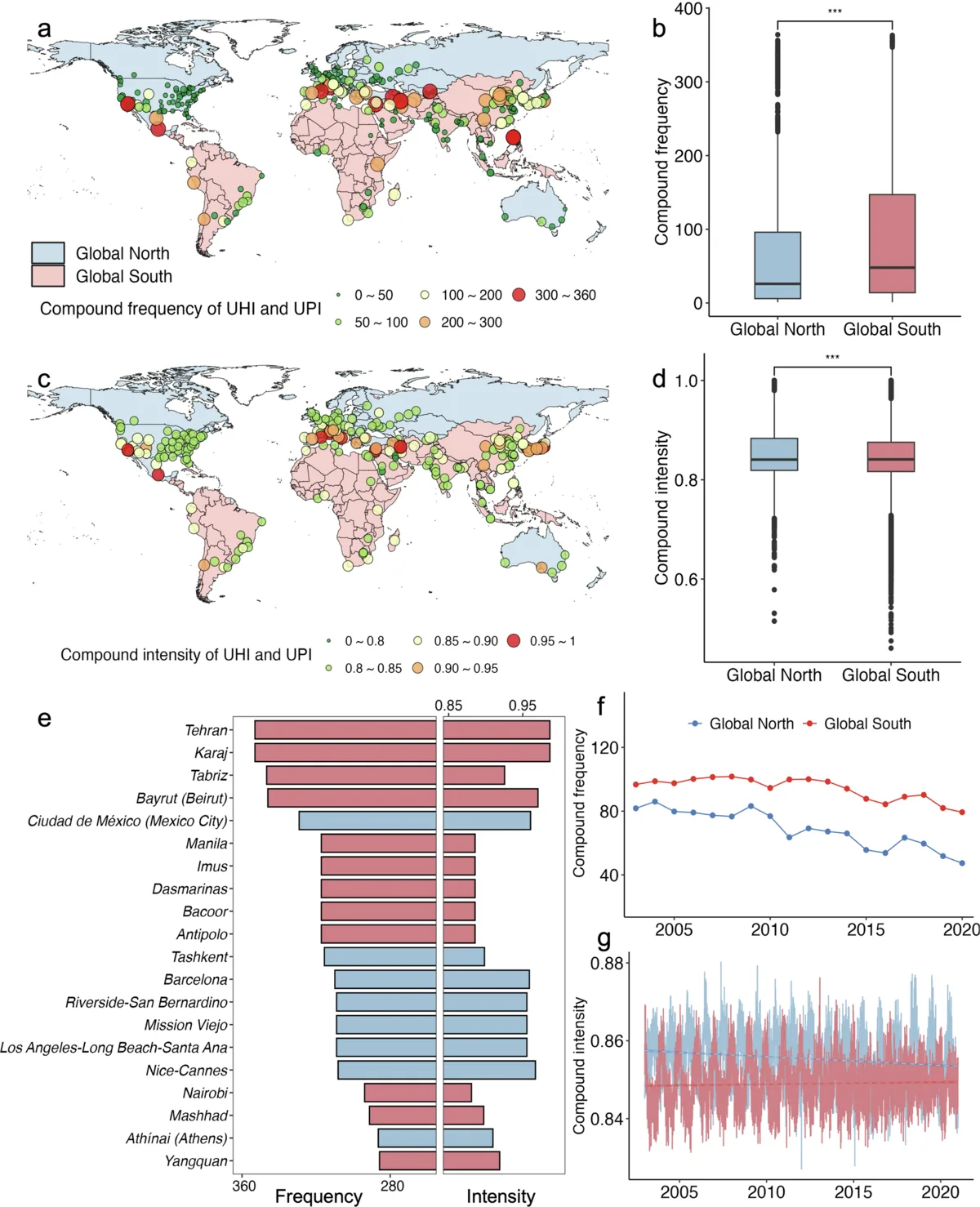
Compound frequency and intensity of urban heat and air-pollution islands in 327 cities, 2003–2020. Fig. 1 of Lin et al. (2026), npj Urban Sustainability (CC BY-NC-ND 4.0).
Selected publications
Climate risk and community resilience
Floods, droughts, and extreme temperatures increasingly arrive together. I map where compound and cascading climate risks concentrate, and use satellite evidence — from disaster-impact records to monthly nighttime lights — to measure how communities are disturbed by shocks and how quickly they recover, with attention to climate vulnerability and environmental justice.
Key questions
- Where are communities least able to absorb compound floods, droughts, and heat extremes?
- Can longitudinal satellite observations reveal resilience — disturbance and recovery — directly?
Methods. Disaster-impact spatialization, random forest, fuzzy-logic integration, time-series analysis of nighttime lights, high-resolution risk assessment
Scale. Community to global (multi-kilometre grids); monthly to multi-decadal
floodsdroughtsextreme temperaturecompound riskcommunity resilienceclimate adaptationenvironmental justice
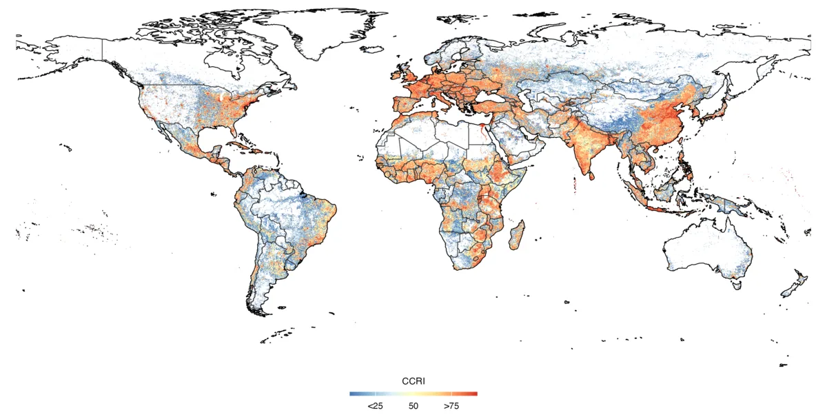
Community-Climate Resilience Index (CCRI) worldwide. From Lin et al. (2026), Earth's Future (CC BY-NC 4.0).
Selected publications
Research vision
My long-term goal is to build high-resolution, explainable, and socially meaningful geospatial evidence — evidence that helps cities and communities adapt to climate extremes, protect public health, and grow more sustainably.
Getting there requires three things at once: observation systems that see every city and settlement consistently; models whose outputs scientists and policymakers can interrogate rather than take on faith; and research questions set by what matters for people — health, safety, and fair access to a livable environment. Each project I take on is chosen to advance at least one of these fronts.